- Selective training 1 year level L3 - 60 ECTS
- Cost of the training :
- Alternating apprenticeship contract: free for the employee
- Alternating work experience contract: 8775 €.
- Continuing education: 11700 €.
- Location: Digne-les-Bains
- International mobility: internship in spring
- Professionalization: Work-study program - Company partnerships
- Graduates' network
- Number of students: 18
*2021 fee for initial training. Exemption for scholarship holders and work-study students
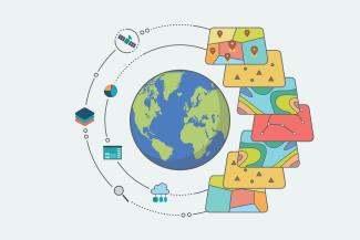
Cette Licence professionnelle a pour objectif de former des cartographes géomaticiens spécialisés en environnement, en espace rural ou en montagne. À la croisée de la géographie et de l'informatique, le géomaticien exploite toutes les données en lien avec un espace géographique. Il intervient dans tous les secteurs qui ont besoin de représentation de données, d'analyse spatiale : urbanisme, environnement, transport, énergie, tourisme, agricole.
Les étudiants exploitent et produisent des données géolocalisées, de l'information géographique, cartographient à destination de clients, usagers.
Ils sont formés aux divers outils de la géomatique pour recueillir, cartographier, croiser, sélectionner des données géographiques, analyse d'images Lidar, au langage SQL, Python, à partir d’une large gamme d'applications informatiques tels que QGis-GRASS, PostGis, ArcGis, FME, Autocad, Inkscape, Studio-R et autres outils libres ou gratuits.
-
How are the studies organized?
- La Licence professionnelle est organisée en approche par compétences. Elle est accessible en alternance uniquement : contrat de professionnalisation, contrat d'apprentissage, en VAE et en Formation continue. Le programme pédagogique est de 450 heures de cours pour les alternants.
- La recherche de contrat en alternance est sous la responsabilité du candidat. Le secrétariat pédagogique dispose d'une liste d'offres en alternance.
- En Formation continue, l'alternance n'est pas obligatoire mais est remplacée par un projet tuteuré (équivalent à 150h) pendant les périodes en entreprise, et par un stage d'une durée minimale de 12 semaines à partir de fin mars.
- La LP SIG est de petit effectif (18 étudiants), avec une forte hétérogénéité des profils. L’entraide y est forte, une diversité qui favorise les échanges, une spécificité entre chacun de ces futurs techniciens géomaticiens.
- Rythme de l'alternance : 3 périodes courtes en entreprise de 3 semaines avec 4 à 6 semaines à l’IUT, et à partir de mi-mars en continue.
-
Internships, work-study and supervised projects
Projets
- Projets tuteurés concernent uniquement les étudiants en formation continue : Projet réalisés entre septembre et mars, suivis par les enseignants, en réponse à une demande professionnelle d’une étude SIG (expérimentation et mise en application des enseignements).
- Les enseignements s'appuient sur des réelles bases de données SIG : études de cas en aménagement du territoire, en environnement. Tous les enseignements sont orientés sur des techniques et méthodes d'expertises en géomatique, de recueil de données, de projets.
Partenaires* :
- Secteur de l’eau : Société Canal de Provence SCP ; VEOLIA ; SUEZ ; Régies de l’eau ;
- Secteur énergie, minerais, construction : GDR ENEDIS ; GRT Gaz ; RTE ; VINCI Construction ; VALOREM, ORANO Minerais ; VOLTALIA ; PARERA
- Secteur du transport, télécommunication : SNCF ; Telecom Orange ;
- Secteur de l’environnement, gestion forestière, des risques : ONF ; RTM, CIRAD ; INAO ; OFB, BRGM ; Fédération Départementale de Chasse ; sociétés de gestion forestière ;
- Secteur du tourisme, du sport : Compagnie des Alpes ; FFRandoPedestre ;
- Bureaux d’études en urbanisme-aménagement, cabinets de géomètres-topographes ; bureaux d’étude de cartographie, de photogrammétrie, etc.
- Services publics, collectivités territoriales : Mairies ; Conseils départementaux ; Conseils régionaux ; Agglomérations; Communautés de communes ; Syndicats Mixtes ; DDT ; SDIS ; CNRS ; INRAE ; IGN ; Parcs Nationaux ; Services de sécurité
* Structures d’accueil d'alternance toute l’année, ou stage
-
International mobility
Alternance avec Mobilité Internationale : il est possible de partir en stage à l'étranger en tant qu’apprenti. La LP SIG accompagne les candidats souhaitant effectuer un stage de 2 mois à l'étranger entre juillet et début octobre. En Europe, une bourse ERASMUS peut être attribuée. L’entreprise qui accueille l'alternant a la possibilité de « mettre en veille » le contrat de travail. Demandez à votre entreprise de vous accorder 2 mois pour travailler ailleurs et découvrir du pays !
-
Certifications
Certification en anglais
Geomatics for the environment, tourism and mountain development
-
Skills
La Licence professionnelle est organisée en approche par compétences. A l’issue de cette Licence professionnelle, les diplômés seront compétents pour :
- Traiter, structurer de l'information géographique
- Développer et exploiter un Système d'Information Géographique (SIG)
- Rechercher et recueillir des bases de données open source
- Conduire des enquêtes, recueillir et produire de la donnée statistique
- Effectuer des relevés terrain géo-référencés
- Se repérer sur la carte, se déplacer sur le terrain, identifier les risques en montagne
- Comprendre des problématiques d’aménagement, d’agronomie et de gestion de l’environnement
- Identifier les enjeux socio-économiques et environnementaux en territoires ruraux ou en montagne
- Sélectionner, strcuturer des bases de données géoréférencées sur requêtes ou de programmation
- Traiter et interpréter des images de télédétection spatiale
- Cartographier des données géographiques
- Elaborer des plans et des cartes d'édition, design graphique
- Produire des cartes numériques, interactives et en ligne- Webmapping
- Appliquer des méthodes d'analyse spatiale de données géographiques
- Conduire un projet en situation professionnelle
- Générer des scénarii prospectifs en tant qu’outil d’aide à la décision ou de prévention de risques
- Apporter une assistance technique en SIG
- Veiller à la pérennité des solutions, à la qualité des données
- S’autoévaluer pour améliorer sa pratique dans le cadre d’une démarche qualité
- Respecter les principes d’éthique, de déontologie et de responsabilité environnementale
- Travailler en équipe, dans un cadre collaboratif et en autonomie
-
Materials
-
Trades
Le professionnel valorisera ses compétences au sein de tout organisme professionnel utilisateur de systèmes d’information géographique (SIG) : secteur de l’environnement, de l’aménagement des territoires et urbanisme, organisme agricole ou forestier, collectivités locales et territoriales, bureau d’études environnementales, parcs naturels régionaux et nationaux, agences de l’eau, entreprises de transport.
Cette Licence professionnelle permet d'accéder aux métiers de :
- Technicien géomaticien
- Cartographe
- Dessinateur
Les entreprises recrutent à niveau bac+3 ! Consulter les offres d'emploi actuelles en géomatique (Sites web Georezo; Indeed). La Licence professionnelle est bien un diplôme d’insertion professionnelle directe.
Certaines offres d'emploi demandent des doubles compétences : technicien forestier et géomaticien ; développeur informatique et géomaticien ; technicien gestion de l'eau et géomaticien ; technicien statisticien et géomaticien; etc. -
Further studies
Pour les meilleurs étudiants, une poursuite d’étude peut être envisagée. Cependant, les cours en licence professionnelle sont, en priorité, techniques et peu théoriques. Les critères de sélections en Master sont variables, selon leurs taux de pression.
Possibilité de poursuites des études en master - en urbanisme, aménagement, information géographique, conduite de projet, télédétection, environnement (si L2 en SVT ou physique), géomarketing, etc. - ou en écoles d'ingénieurs forestiers, ingénieurs géomètres-topographes (Institut nationale des Sciences Appliqués -INSA, etc.)
Application
Vous êtes titulaire d’un Bac+2 et vous avez un projet professionnel qui fait appel à des compétences en cartographie, géomatique (SIG) ? Tous les profils, sont accueillis, en alternance ou en formation continue.
Déposez votre candidature, ensuite, vous trouverez un contrat en alternance.
Les candidatures sont ouvertes du 1er mars au 30 juin.
Sur E-Candidat, déposez :
- CV
- Lettre de motivation
- Relevés de notes du Bac, Bac+1 et Bac+2
- Copie de carte d’identité
Contrats en alternance :
- Candidats de -30 ans ou en RQTH : Alternance en contrat d'apprentissage ou de professionnalisation.
- Candidats de plus de 30 ans : Inscription en alternance en contrat de Professionnalisation ou bien en Formation Continue.
- Formation Continue : Prise en charge des frais d'inscription variable selon votre situation.
Profile of the candidates
La sélection des candidats se fait sur dossier de titulaires de BAC+2 technique ou scientifique ou niveau équivalent reconnu par la Commission de Validation des Acquis. Les profils particulièrement adaptés sont diplômés de Bac + 2 technique ou scientifique et de certaines filières des sciences humaines :
- Licence 2 : Géographie, SM, SVT, STU, MIASS, Informatique, Sociologie
- DUT/BUT : Génie Biologique, Génie Civil, HSE, Statistique Informatique, Statistiques
- BTS secteurs Gestion de l'eau, Gestion forestière, GPN, Environnement, Aménagement, Agricole, Informatique, Topographie
Tous les profils à partir de Bac+2 peuvent être recevables. Votre candidature doit mentionner un vif intérêt à la géomatique, aux données, à l’informatique en général. N’hésitez à mentionnez votre expérience sur les logiciels SIG, etc.
Aucun prérequis en SIG est attendu. Les débutants sont les bienvenus !
PRACTICAL INFORMATION
Adresse : 19 Boulevard Saint-Jean Chrysostome - 04000 Digne-les-Bains
CONTACTS


NEWS
-
OpenStreetMap Health Mapping Event 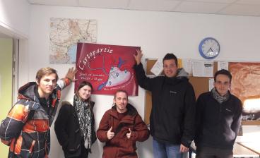
OpenStreetMap Health Mapping Event
The students of the LP SIG Géomatique animated a cartopartie on OpenStreetMap on the theme of health, during the Salon de la domotique at the Lycée Pierre Gilles de Gennes in Digne-les-Bains. -
Discover our new corporate brochure! 
Discover our new corporate brochure!
A summary of the Aix-Marseille IUT in just a few pages: leaf through our new institutional brochure to find out all about the courses and sites, actions with and for companies, university research con […]

